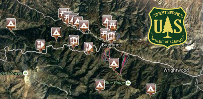
Get Back To Nature. 10 Places To Camp Near Mountain High.
Mountain High is not only LA’s closest winter resort, it’s an easy getaway from the concrete jungle. With camping available at 10 different sites near the resort (“glamping” sites available) you are bound to find a place that suits your senses. Sit back and relax as you cast your line into Jackson Lake, enjoy an easy day-hike on one of the nearby trails, or get crazy on the Pacific Crest Trail and conquer as much of the 2,659 mile trek as you can in a weekend. Biking is also available on designated trails, so there’s plenty for you to discover and explore as you get back to the outdoors. http://www.fs.usda.gov/main/angeles/home
Appletree Campground
Located on Big Pines Highway approximately 2 miles west of Big Pines, CA. Groceries and services available in the community of Wrightwood (approximately 5 miles). 8 tent sites. 6,200-foot elevation. Fishing in nearby Jackson Lake. No water. Vault toilets. Adventure Pass required for vehicles parked at this campground. Individual campsites are first come - first served. http://www.fs.usda.gov/recarea/angeles/recarea/?recid=41722
Blue Ridge Campground
From Angeles Crest Highway (Hwy. 2), approx. 5 miles west of Wrightwood, take Blue Ridge Road 3 miles to the campground. 8000-foot elevation. 8 campsites. Picnicking at nearby Jackson Lake. Hiking access to the Pacific Crest National Scenic Trail. No piped water. Vault toilets. RV use in the summer months only. RV's to 20'. Sites are first come - first served. Adventure Pass required for vehicles parked at this campground. Call (661) 269-2808 for current conditions and additional information. http://www.fs.usda.gov/recarea/angeles/recarea/?recid=41726
Cabin Flat Campground – Closed –
From Angeles Crest Highway (Hwy. 2), approximately 1.5 miles west of Big Pines, take Blue Ridge Road 5 miles to Guffy Campground, then walk in another 6 miles to Cabin Flat. The road is a rough dirt road - after the first 5 miles a four-wheel drive is required. 5,300-foot elevation. Hike, Mountain Bike or Horseback in only. Trail camp not maintained. No water. Treat stream water before using, if available. Vault toilet. Adventure Pass required for vehicles parked along road. Campsites are first come - first served. Groceries and services available in the community of Wrightwood (approximately 9.5 miles). http://www.fs.usda.gov/recarea/angeles/recarea/?recid=41728
Guffy Campground
Located on Blue Ridge Road 6 miles from the intersection of Blue Ridge Rd. and Angeles Crest Highway (the intersection is 1.5 miles west of Big Pines). The road into the campground is a rough dirt road - after the first 5 miles a four-wheel drive is required. 8,300-foot elevation. 6 trailside campsites overlooking the Sheep Mountain Wilderness Area. Primitive tent camping site overlooking the Sheep Mountain Wilderness Area. No water. Vault toilets. Adventure Pass required for vehicles parked at this campground. Campsites are first come - first served. Groceries and services available in the community of Wrightwood (approximately 9.5 miles). http://www.fs.usda.gov/recarea/angeles/recarea/?recid=41730
Jackson Flat Campground
Located north of State Highway 2 approximately 8 miles west of Wrightwood, CA and one mile beyond a locked gate at Grassy Hollow Visitor Center and picnic area. 7500-foot elevation. Walk in about 200 yards to 5 group tent areas, which accommodate 40-50 people each. Picnicking at nearby Jackson Lake. A spur trail connects to the Pacific Crest National Scenic Trail. Parking is limited and carpooling is recommended. All sites have piped water, and group-sized tables. Flush toilets are provided within easy walking distance of all sites. An observation deck and two nature trails are located within the campground. A trail to Jackson Lake leads from the campground for those who prefer a lengthier hike The campground is available on a reservation basis only and is operated by concessionaires. Reservations may be made by contacting the National Recreation Reservation Service at (877) 444-6777 or TDD (877) 833-6777. For more information concerning the campground call (760) 249-3526. Adventure Pass required for parking in the forest. http://www.fs.usda.gov/recarea/angeles/recarea/?recid=41786
Lake Campground
Located on Big Pines Highway (County Rd. N4) 2.5 miles west of Big Pines, CA. Elevation: 6,100', 8 Sites. Piped water during summer months, vault toilets, tables. RV's to 18'. Groceries and services available in the community of Wrightwood. For information and reservations, call National Recreation Reservation Service at 877-444-6777 (TDD 877-833-6777). You may be asked to specify the following: 1.) Angeles National Forest 2.) Big Pines Recreation Area 3.) Wrightwood, CA 4.) Name of Campground. (Reservations may be made May 15-Sept. 15.) http://www.fs.usda.gov/recarea/angeles/recarea/?recid=41680
Lupine Campground – Open/Closed
Contact Ranger before heading out - From Angeles Crest Highway (Hwy. 2), approx. 5 miles west of Wrightwood, take Blue Ridge Road and drive approximately 5 miles to locked gate, walk 3 miles in to campground. No water. Campsites are first come - first served. Vault toilets. Adventure Pass required for vehicles. http://www.fs.usda.gov/recarea/angeles/recarea/?recid=41732
Mount Oak Campground
Located on Big Pines Highway (Co. road N4) 3 miles from Big Pines, CA. 6,200-foot elevation. 17 sites on Big Pines highway. Fishing in nearby Jackson Lake. Piped water in summer months, fire pits, tables and flush toilets. RV's to 18'. Adventure Pass required for vehicles parked at this campground. Groceries and services available in the community of Wrightwood (approximately 8 miles). You may be asked to specify the following: 1.) Angeles National Forest 2.) Big Pines Recreation Area 3.) Wrightwood, CA 4.) Name of Campground. (Reservations may be made May - Nov.). http://www.fs.usda.gov/recmain/angeles/recreation
Peavine Campground
Located on Big Pines Highway (County Rd. N4) 2 miles west of Big Pines, CA. Usually inaccessible during the winter months. http://www.fs.usda.gov/recarea/angeles/recarea/?recid=41734
Table Mountain Campground
Located next to the Mountain High North Resort. Open late April/early May to first week in November. Picnic tables, Potable Water, Flush Toilet, Pit. Right next to the Mountain High North Lodge and resort. Sky High Disc Golf. This site can be reserved by calling Toll Free 1-877-444-6777 (International 518-885-3639 or TDD 877-833-6777) http://www.fs.usda.gov/recarea/angeles/recarea/?recid=41684
Mountain Bike Guide
Blue Ridge Trail – Intermediate smooth single track (out and back), approximately 4 miles round trip from Hwy 2 to Blue Ridge Campground and back. 1,000 ft elevation gain in 2 miles. Forested trail with spring wildflowers or fall colors.
Dawson Saddle Trail – Intermediate smooth single track (out and back), A great single track with spectacular views and only 920 feet of elevation gain in 2 miles. Approximately 4 miles round trip from Hwy 2.
Grassy Hollow to Vincent Gap – Beginner dirt road (out and back or shuttle), 3 miles one way, gentle grade on seldom used paved and dirt road. Great views of mountains and desert, wild flowers in spring.
Guide To Day Hikes
Lightning Ridge Nature Trail – Easy Hike. 1 mile loop nature trail.
Blue Ridge Trail – Moderate Hike, 4 miles round-trip from Highway 2 to Blue Ridge campground and back. 1,000 foot elevation gain. Mostly forested trail with wildflowers in spring and some fall colors.
Mt. Baden Powell Trail – Strenuous Hike, 8 miles round trip from Highway 2 to summit and back. 2,000 foot elevation gain. Great views of ocean, mountain and desert.


