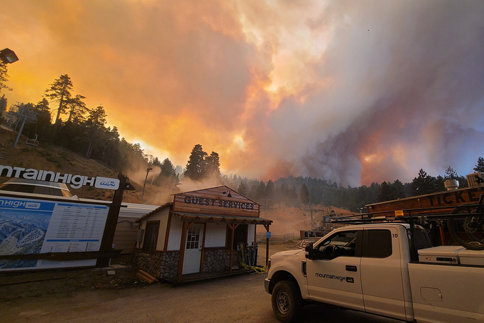
Thank you to all the Firefighters and employees who worked tirelessly to save Mountain High. There is a lot of work to be done but nothing that would keep us from opening in November or providing the level of service you expect. Please keep in touch with us here as we evaluate the damage and plot our course forward.
Bridge Fire Website: //inciweb.wildfire.gov/incident-information/caanf-bridge-fire
Interactive maps for residents affected by the Bridge Fire.
For San Bernardino County: //prepare.sbcounty.gov/bridge-fire/
For Los Angeles County: //recovery.lacounty.gov/bridgefire/
Fire Information: (626) 662-0120
Email: 2024.Bridge@firenet.gov
Fire Size: 54,795 acres
Percent Contained: 41%
Personnel: 2,549
Injuries: 4
Structures Damaged: 19
Structures Destroyed: 81
Cause: Under investigation
September 11, 2024


The Bridge Fire moved through parts of Mountain High Resort overnight. As of 11 a.m. this morning, reports indicate that base facilities at all 3 Resorts (East, West, & North) remain intact. Los Angeles County Fire Station 130, stationed at the West Resort, has been credited with the incredible work of defending the property. The captain of Engine 130 also confirmed that the building and restaurant at the top of East Resort survived the fire.
“We are grateful beyond words for the swift and courageous actions of Los Angeles County Fire Department Division 5 and all the first responders working tirelessly to protect our resort and community,” said John McColly, Vice President of Sales & Marketing for the California Mountain Resort Co. “We stand in solidarity with everyone affected by the Caanf Bridge Fire and other fires burning throughout the State. We are committed to supporting our community and plan to come out of this tragedy stronger than ever.”
The resort is still assessing the situation but anticipates opening on time for the upcoming season. An official opening date has not been set. Opening is weather-dependent but could be anytime after November 1st.
This is still an active fire and the situation could change. Mountain High continues to work closely with the Unified Command, which includes CAL FIRE, Los Angeles County Fire, and the San Bernardino County Fire, among others. The safety of staff, guests, and the surrounding community remains the top priority.
Download the App to stay connected with Mountain High. Get the latest fire updates plus live cams, weather forecasts, and more.
The situation remains fluid so keep in touch with us here for the latest fire alerts. Mountain High will provide updates as credible information becomes available.
September 12, 2024
- Camping is closed indefinitely.
- The North Lodge is closed for the summer. We expect to re-open Friday, September 20th. Please join us then.
- Mountain Bike Sneak Peak is CANCELED. We're sorry mountain bikers. We'd love to see you but we've got a lot of work ahead and our employees are focused on different things. We'll see you in the Spring.
- Oktoberfest is CANCELED. The North Lodge is safe but we are canceling this season's event so we can focus on fire clean-up and our winter opening. See you soon.
EVACUATION ORDERS
- Hwy 138 south to Lone Pine Canyon and Highway 2 east to Lone Pine Canyon Road.
- Piñon Hills from Wrightwood north to Highway 18 and Beekley Road west to LA County.
- Lone Pine Canyon from the community of Wrightwood to Highway 138/Lone Pine Canyon Road south to the forest.
- Entire community of Wrightwood.
- East Fork communities of Camp Williams Resort (café, mobile home park, campground) and River Community (near the resort).
- Mt. Baldy Road, North Mountain Avenue and Shinn Roads from San Antonio heights to Wrightwood and east to Cucamonga Peak
CLOSURES
- SR-138 from Lone Pine Canyon Road to Beekley Road
- SR-2 closed from Big Pines to SR-138
- Big Pines Highway
- Big Rock Creek Road
- San Gabriel Canyon and East Fork of the San Gabriel River
- Highway 39
- East Fork Road
- Glendora Ridge Road
- Glendora Mountain Road
- Mt. Baldy Road at Shinn Road intersection
WEATHER
Coastal marine influence and favorable onshore winds will aid firefighters in direct attack as fire backs downhill for most of the west half of the fire’s perimeter. However, at the higher elevations humidity will still be low and the desert areas will not have much humidity recovery. Overall, air masses are becoming more stable which will moderate fire behavior. For information on smoke impacts and an interactive map, visit fire.airnow.gov.
September 13, 2024
How Mountain High Saved Itself From a 45,000 Acre Wildfire - Read this great article by Outside Magazine.
Due to excellent work by firefighters and moderating weather, containment has now been confirmed at 3% in the southwestern flank on the Bridge Fire with minimal growth in acreage. The north flank of the fire is the number one priority in halting acreage growth, as well as continuing structure protection in Piñon Hills, Wrightwood, and Mount Baldy Village. On the northeast flank, the top priority is to keep the fire out of Lytle Creek. With a total of 15 helicopters assigned to this incident including four from the National Guard, aviation crews plan to focus on dropping water and fire retardant heavily in the northwest flank where the fire is currently the most active.
With the extremely steep terrain and lower humidities remaining in the higher elevations, firefighters will prioritize direct attack tactics to stop the rollout of burning vegetation causing spot fires below. Aircraft will be concentrating on dropping water and fire retardant on the northwest flank. Due to the rugged and steep terrain on the western flank of the fire, aircraft will continue monitoring for any heat signatures where ground crews cannot be inserted.
With the help of the marine layer increasing humidity in the lower elevations and favorable onshore winds, firefighters are making great progress in strengthening both primary and secondary containment lines in the southeast, south, and southwest flanks of the fire, while also gaining depth in their mop up operations.
September 16, 2024
Firefighters made significant progress last night with much colder temperatures, higher humidity, and minimal growth. In all areas of the fire, crews will prioritize securing and validating containment lines today to further increase the containment percentage and get residents back into their homes where hazards have been cleared. Strike teams of engines and hand crews, water tenders, and falling modules have been ordered to continue assisting fire personnel, along with air resources that have continued to support boots on the ground.
In the Wrightwood area, safety hazards remain while firefighters continue mop-up operations and falling trees. Residents remain under an evacuation order until these hazards are cleared for the public and utilities are restored.
September 17, 2024
The Evacuation Order Has Been Reduced To Residents Only.
The mandatory evacuation order has been reduced to an evacuation warning for Wrightwood. Residents-only are being allowed to return with identification. AREAS BEYOND LA COUNTY LINE AND THROUGH OUR CAMPGROUNDS ARE STILL UNDER MANDATORY EVACUATION. There are still multiple hot spots in the vicinity of the resort and our parking lots are still being used as command center for fire crews and infrastructure repair trucks. We only have a small crew working on equipment/property damage evaluation. All other employees are on standby at this time.
September 20, 2024
Entry into Wrightwood is now UNRESTRICTED. However, Hwy 2 is still CLOSED between Wrightwood and the East Resort. Employees are being allowed through.
Rain is forecasted today into the late afternoon, with a chance of thunderstorms. The storms are likely to be slow-moving with lower wind speeds. Members of the public in and near recently burned areas are asked to be prepared for the possibility of debris flow. Over the coming weekend, a warming and drying trend will begin, reducing relative humidities in the area. Rain is forecasted today into the late afternoon, with a chance of thunderstorms. The storms are likely to be slow-moving with lower wind speeds. Members of the public in and near recently burned areas are asked to be prepared for the possibility of debris flow. Over the coming weekend, a warming and drying trend will begin, reducing relative humidities in the area.
September 26, 2024
This is the FINAL update for the Bridge Fire. For any additional updates, visit: https://inciweb.wildfire.gov/incident-information/caanf-bridge-fire.
Hot, dry weather continues today and will likely cause some unburned pockets of fuel to flare up. When this happens, smoke may be visible in the fire interior. Firefighters will continue mopping up, investigating smoke, and extinguishing isolated heat sources. Hazardous trees will also be removed to improve public and crew safety.


